| Location |
| City: | | Helena, Montana, United States |
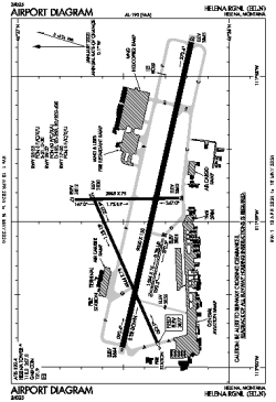
| Name: | Helena Regional |
| ICAO / IATA: | KHLN / HLN |
| FAA: | HLN |
Details |
| Type: | Airport (Part 139 Class I) |
| Use: | Public/Civil |
| Latitude: | 46°36'24"N (46.606722) |
| Longitude: | 111°59'00"W (-111.983277) |
| Datum: | WGS 1984 |
| Elevation: | 3877 ft (1182 m) |
| Runways: | 4 |
| Longest: | 9000 × 150 ft (2743 × 45.5 m) |
Time |
| Timezone: | UTC+27:08 (DST+30:08) |
| Local Time: | |
Weather |
| METAR: | KHLN | 041353Z 27009KT 10SM OVC031 M23/M28 A2982 RMK AO2 SLP214 T12331278
|
| TAF: | KHLN | 041132Z 0412/0512 27008KT P6SM VCSH SCT025 OVC035
FM041500 VRB05KT 6SM -SHSN BR SCT015 OVC025
FM042000 35005KT P6SM VCSH SCT025 OVC050
FM050300 31007KT 4SM -SN BR BKN015 OVC025
|
Related Locations |
| Nearby: | |
| Farthest: | FAME: 11016 mi / 17729 km
Marion Island, Prince Edward Islands, WC, ZA |
Find: |
|
Other Information |
Maps:
|
Delays:
|
Links:
|
Sources:
|
|