| Location |
| City: | | Khanty-Mansiysk, Khanty-Mansiyskiy, Russian Federation (Russia) |
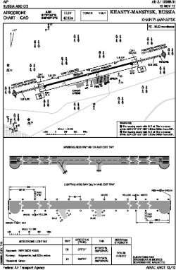
| Name: | Khanty-Mansiysk Airport |
| ICAO / IATA: | USHH / HMA |
Details |
| Type: | Airport (Aerodrome, Airfield) |
| Use: | Public/Civil |
| Latitude: | 61°01'43"N (61.028611) |
| Longitude: | 69°05'10"E (69.086111) |
| Elevation: | 141 ft (43 m) |
| Runways: | 1 |
| Longest: | 9186 × 148 ft (2800 × 45 m) |
Time |
| Timezone: | UTC+5 (DST+6) |
Weather |
| METAR: | USHH | 041400Z 31001MPS 9999 BKN010 M27/M30 Q1045 R24/490540 TEMPO 1000 BR BKN004 RMK QFE780
|
| TAF: | USHH | 041351Z 0415/0515 32003MPS 9999 BKN011 TEMPO 0415/0506 VRB01MPS 2000 BR FU SCT002 BKN011 TEMPO 0506/0515 3100 -SN BR SCT003 OVC011
|
Related Locations |
| Nearby: | |
| Farthest: | NEMO: 11459 mi / 18441 km
Pacific Ocean [Oceanic Pole of Inaccessibility (Point Nemo)] |
Find: |
|
Other Information |
Maps:
|
Links:
|
Sources:
|
|