| Location |
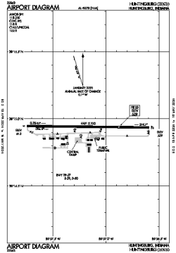
| City: | | Huntingburg, Indiana, United States |
| ICAO / IATA: | KHNB / HNB |
| FAA: | HNB |
Details |
| Type: | Airport (Airfield) |
| Use: | Public/Civil |
| Latitude: | 38°14'56"N (38.249017) |
| Longitude: | 86°57'10"W (-86.952818) |
| Datum: | WGS 1984 |
| Elevation: | 529 ft (161 m) |
| Runways: | 1 |
| Longest: | 5501 × 100 ft (1677 × 30.5 m) |
Time |
| Timezone: | UTC+28:08 (DST+31:08) |
| Local Time: | |
Weather |
| METAR: | KHNB | 041413Z AUTO 18011KT 10SM BKN016 BKN030 OVC085 12/10 A2989 RMK AO2
|
| TAF: | KHNB | 041135Z 0412/0512 17008KT P6SM SCT100
FM041400 18012G19KT 5SM BR VCSH BKN025 OVC100 TEMPO 0417/0421 2SM -SHRA BR BKN009
FM042200 20011G20KT 5SM -RA OVC008
FM050000 22008KT P6SM VCSH OVC007
FM051000 35008KT P6SM BKN008
|
Related Locations |
| Nearby: | |
| Farthest: | YAUG: 11183 mi / 17997 km
Augusta [Augusta Airport], WA, AU |
Find: |
|
Other Information |
Maps:
|
Links:
|
Sources:
|
|