| Location |
| City: | | Mattala, Southern Province, Sri Lanka (Ceylon) |
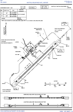
| Name: | Mattala Rajapaksa International Airport |
| ICAO / IATA: | VCRI / HRI |
Details |
| Type: | Airport (Aerodrome, Airfield) |
| Use: | Public/Civil |
| Latitude: | 6°17'04"N (6.284467) |
| Longitude: | 81°07'27"E (81.124128) |
| Elevation: | 157 ft (48 m) |
| Runways: | 1 |
| Longest: | 11483 × 197 ft (3500 × 60 m) |
Time |
| Timezone: | UTC+5:30 (DST+7:30) |
| Local Time: | |
Weather |
| METAR: | VCRI | 041410Z 02005KT 9999 SCT017 OVC079 25/25 Q1014 NOSIG
|
| TAF: | VCRI | 041100Z 0412/0518 03008KT 9999 SCT018 TX30/0508Z TN24/0500Z TEMPO 0412/0415 8000 -SHRA SCT016 BKN060 BECMG 0504/0506 06012G22KT PROB40 TEMPO 0509/0515 7000 -TSRA/SHRA SCT016 FEW018CB
|
Related Locations |
| Nearby: | |
| Farthest: | SEII: 11785 mi / 18967 km
Puerto Villamil [General Villamil], Isabela Island, W, EC |
Find: |
|
Other Information |
Maps:
|
Links:
|
Sources:
|
|