| Location |
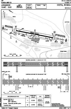
| City: | | Chita, Zabaykal'skiy, Russian Federation (Russia) |
| Name: | Kadala Airport |
| ICAO / IATA: | UIAA / HTA |
Details |
| Type: | Airport (Aerodrome, Airfield) |
| Use: | Public/Civil |
| Latitude: | 52°02'N (52.027) |
| Longitude: | 113°18'E (113.305) |
| Elevation: | 2272 ft (693 m) |
| Runways: | 1 |
| Longest: | 9186 × 184 ft (2800 × 56 m) |
Time |
| Timezone: | UTC+9 (DST+10) |
Weather |
| METAR: | UIAA | 041400Z AUTO 25003MPS 9999 NCD M27/M36 Q1017 RMK QFE704/0939
|
| TAF: | UIAA | 041400Z 0415/0515 26003MPS 9999 NSC TEMPO 0415/0503 3100 BR= TAF UIBB 041400Z 0415/0515 30003MPS 3500 BR FEW003 SCT020 TEMPO 0415/0503 0800 FG VV002 BECMG 0503/0505 9999 NSW SCT016
|
Related Locations |
| Nearby: | |
| Farthest: | SHDG: 12359 mi / 19890 km
Magallanes [Batería Dúngenes 1 Heliport], MA, CL |
Find: |
|
Other Information |
Maps:
|
Sources:
|
|