| Location |
| City: | | Terre Haute, Indiana, United States |
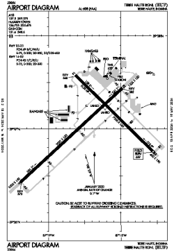
| Name: | Terre Haute Regional |
| ICAO / IATA: | KHUF / HUF |
| FAA: | HUF |
Details |
| Type: | Airport (Part 139 Class IV) |
| Use: | Public/Civil |
| Latitude: | 39°27'02"N (39.450632) |
| Longitude: | 87°18'25"W (-87.306989) |
| Datum: | WGS 1984 |
| Elevation: | 589 ft (180 m) |
| Runways: | 2 |
| Longest: | 9021 × 150 ft (2750 × 45.5 m) |
Time |
| Timezone: | UTC+29:08 (DST+32:08) |
| Local Time: | |
Weather |
| METAR: | KHUF | 041410Z 18011G18KT 10SM BKN016 OVC065 11/09 A2983 RMK AO2 T01110089
|
| TAF: | KHUF | 041123Z 0412/0512 17010KT P6SM BKN070 WS020/21035KT
FM041300 17011KT P6SM VCSH OVC020
FM041900 20011G19KT P6SM VCSH OVC008
FM050200 30009KT P6SM OVC008
FM050700 34009KT P6SM BKN010
FM051100 01007KT P6SM BKN015
|
Related Locations |
| Nearby: | |
| Farthest: | YAUG: 11153 mi / 17948 km
Augusta [Augusta Airport], WA, AU |
Find: |
|
Other Information |
Maps:
|
Links:
|
Sources:
|
|