| Location |
| City: | | Havre, Montana, United States |
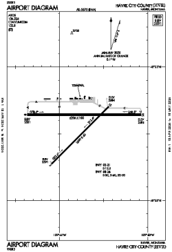
| Name: | Havre City-County Airport |
| ICAO / IATA: | KHVR / HVR |
| FAA: | HVR |
Details |
| Type: | Airport (Airfield) |
| Use: | Public/Civil |
| Latitude: | 48°32'35"N (48.542985) |
| Longitude: | 109°45'44"W (-109.762341) |
| Datum: | WGS 1984 |
| Elevation: | 2591 ft (790 m) |
| Runways: | 2 |
| Longest: | 5205 × 100 ft (1586 × 30.5 m) |
Time |
| Timezone: | UTC+27:08 (DST+30:08) |
| Local Time: | |
Weather |
| METAR: | KHVR | 041353Z AUTO 07006KT 10SM SCT075 M24/M27 A3010 RMK AO2 SNB1258E25 SLP270 P0000 T12391267
|
| TAF: | KHVR | 041132Z 0412/0512 VRB05KT P6SM VCSH SCT050 OVC080 TEMPO 0413/0416 6SM -SHSN BR SCT025 BKN040 OVC050
FM041600 VRB06KT 3SM -SN BR SCT008 BKN015 OVC025
FM050200 06007KT 6SM -SHSN SCT015 OVC025
FM050800 03008KT 3SM -SN BR BKN015 OVC025
|
Related Locations |
| Nearby: | |
| Farthest: | FAME: 10936 mi / 17600 km
Marion Island, Prince Edward Islands, WC, ZA |
Find: |
|
Other Information |
Maps:
|
Links:
|
Sources:
|
|