| Location |
| City: | | Niagara Falls, New York, United States |
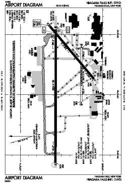
| Name: | Niagara Falls International Airport |
| ICAO / IATA: | KIAG / IAG |
| FAA: | IAG |
Details |
| Type: | Airport (Part 139 Class I) |
| Use: | Public/Civil |
| Latitude: | 43°06'27"N (43.107557) |
| Longitude: | 78°56'45"W (-78.945846) |
| Datum: | WGS 1984 |
| Elevation: | 592 ft (180 m) |
| Runways: | 3 |
| Longest: | 9826 × 150 ft (2995 × 45.5 m) |
Time |
| Timezone: | UTC+29:08 (DST+32:08) |
| Local Time: | |
Weather |
| METAR: | KIAG | 041353Z 00000KT 10SM OVC049 08/03 A2994 RMK AO2 SLP146 T00780028
|
| TAF: | KIAG | 041131Z 0412/0512 22012KT P6SM OVC040 WS020/24040KT
FM041400 21010KT P6SM OVC040
FM041800 19009KT P6SM BKN250
FM050000 19016G23KT P6SM OVC060 WS020/21045KT
FM050200 19019G31KT 6SM -SHRA OVC012 WS020/21050KT
FM050500 22018G29KT P6SM VCSH OVC012
|
Related Locations |
| Nearby: | |
| Farthest: | YAUG: 11466 mi / 18453 km
Augusta [Augusta Airport], WA, AU |
Find: |
|
Other Information |
Maps:
|
Links:
|
Sources:
|
|