| Location |
| City: | | Wilmington, Delaware, United States |
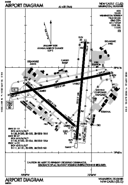
| Name: | New Castle Airport |
| ICAO / IATA: | KILG / ILG |
| FAA: | ILG |
Details |
| Type: | Airport (Part 139 Class I) |
| Use: | Public/Civil |
| Latitude: | 39°40'43"N (39.678710) |
| Longitude: | 75°36'24"W (-75.606634) |
| Datum: | WGS 1984 |
| Elevation: | 79 ft (24 m) |
| Runways: | 3 |
| Longest: | 7275 × 150 ft (2217 × 45.5 m) |
Time |
| Timezone: | UTC+29:08 (DST+32:08) |
| Local Time: | |
Weather |
| METAR: | KILG | 041351Z 00000KT 3SM BR CLR 02/M01 A3011 RMK AO2 SLP197 T00171006
|
| TAF: | KILG | 041120Z 0412/0512 VRB03KT 4SM BR SCT250
FM041400 VRB03KT P6SM SCT250
FM050300 VRB03KT 6SM BR BKN200
FM050700 VRB03KT 4SM BR OVC150
|
Related Locations |
| Nearby: | |
| Farthest: | YAUG: 11740 mi / 18893 km
Augusta [Augusta Airport], WA, AU |
Find: |
|
Other Information |
Maps:
|
Delays:
|
Links:
|
Sources:
|
|