| Location |
| City: | | Ithaca, New York, United States |
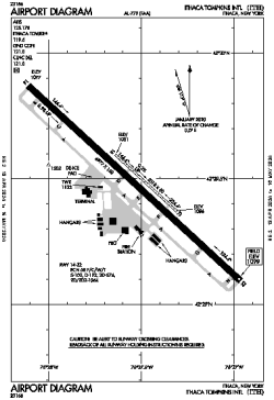
| Name: | Ithaca Tompkins International Airport |
| ICAO / IATA: | KITH / ITH |
| FAA: | ITH |
Details |
| Type: | Airport (Part 139 Class I) |
| Use: | Public/Civil |
| Latitude: | 42°29'29"N (42.491361) |
| Longitude: | 76°27'31"W (-76.458721) |
| Datum: | WGS 1984 |
| Elevation: | 1099 ft (335 m) |
| Runways: | 2 |
| Longest: | 6977 × 150 ft (2127 × 45.5 m) |
Time |
| Timezone: | UTC+29:08 (DST+32:08) |
| Local Time: | |
Weather |
| METAR: | KITH | 041356Z 14007KT 10SM BKN050 07/03 A3001 RMK AO2 SLP166 T00720028
|
| TAF: | KITH | 041132Z 0412/0512 17006KT P6SM OVC060
FM041800 17005KT P6SM SCT120
FM050400 18010G18KT 6SM -SHRA OVC050
FM050900 21008KT P6SM OVC030
|
Related Locations |
| Nearby: | |
| Farthest: | YAUG: 11593 mi / 18657 km
Augusta [Augusta Airport], WA, AU |
Find: |
|
Other Information |
Maps:
|
Delays:
|
Links:
|
Sources:
|
|