| Location |
| City: | | Jackson, Wyoming, United States |
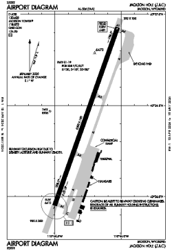
| Name: | Jackson Hole Airport |
| ICAO / IATA: | KJAC / JAC |
| FAA: | JAC |
Details |
| Type: | Airport (Part 139 Class I) |
| Use: | Public/Civil |
| Latitude: | 43°36'26"N (43.607333) |
| Longitude: | 110°44'16"W (-110.737749) |
| Datum: | WGS 1984 |
| Elevation: | 6450 ft (1966 m) |
| Runways: | 1 |
| Longest: | 6300 × 150 ft (1920 × 45.5 m) |
Time |
| Timezone: | UTC+27:08 (DST+30:08) |
| Local Time: | |
Weather |
| METAR: | KJAC | 041414Z 22007KT 1SM -SN BR BKN007 OVC012 M02/M02 A2951 RMK AO2 CIG 004V010 P0000
|
| TAF: | KJAC | 041136Z 0412/0512 20010KT 1 1/2SM -SN SCT005 OVC012 TEMPO 0412/0415 1/2SM SN BKN005
FM050000 21008KT 3SM -SN SCT015 OVC028 AMD LTD TO CLD VIS AND WIND
|
Related Locations |
| Nearby: | |
| Farthest: | FAME: 10902 mi / 17544 km
Marion Island, Prince Edward Islands, WC, ZA |
Find: |
|
Other Information |
Maps:
|
Links:
|
Sources:
|
|