| Location |
| City: | | Jamestown, New York, United States |
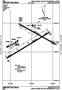
| Name: | Chautauqua County/Jamestown Airport |
| ICAO / IATA: | KJHW / JHW |
| FAA: | JHW |
Details |
| Type: | Airport (Part 139 Class IV) |
| Use: | Public/Civil |
| Latitude: | 42°09'12"N (42.153394) |
| Longitude: | 79°15'29"W (-79.258022) |
| Datum: | WGS 1984 |
| Elevation: | 1723 ft (525 m) |
| Runways: | 2 |
| Longest: | 5300 × 100 ft (1615 × 30.5 m) |
Time |
| Timezone: | UTC+29:08 (DST+32:08) |
| Local Time: | |
Weather |
| METAR: | KJHW | 041356Z AUTO 21008KT 10SM CLR 08/02 A2998 RMK AO2 SLP165 T00780022
|
| TAF: | KJHW | 041131Z 0412/0512 19007KT P6SM OVC040
FM041500 18010G17KT P6SM SCT250
FM050000 19013G20KT P6SM OVC080 WS020/21040KT
FM050300 19016G24KT 6SM -SHRA OVC007 WS020/20045KT
FM050500 20014G20KT P6SM VCSH OVC007
FM050800 24010G18KT P6SM OVC003
|
Related Locations |
| Nearby: | |
| Farthest: | YAUG: 11489 mi / 18489 km
Augusta [Augusta Airport], WA, AU |
Find: |
|
Other Information |
Maps:
|
Links:
|
Sources:
|
|