| Location |
| City: | | Aberdeen, South Dakota, United States |
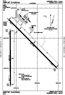
| Name: | Aberdeen Regional |
| ICAO / IATA: | KABR / ABR |
| FAA: | ABR |
Details |
| Type: | Airport (Part 139 Class I) |
| Use: | Public/Civil |
| Latitude: | 45°26'48"N (45.446798) |
| Longitude: | 98°25'21"W (-98.422440) |
| Datum: | WGS 1984 |
| Elevation: | 1301 ft (397 m) |
| Runways: | 2 |
| Longest: | 6901 × 100 ft (2103 × 30.5 m) |
Time |
| Timezone: | UTC+28:08 (DST+31:08) |
| Local Time: | |
Weather |
| METAR: | KABR | 041353Z AUTO 31016KT 8SM CLR M22/M26 A3006 RMK AO2 SLP217 T12221261 $
|
| TAF: | KABR | 041139Z 0412/0512 32017G25KT P6SM FEW015 SCT100 TEMPO 0412/0416 4SM BLSN
FM042200 33013KT P6SM SCT150
FM050000 34010KT P6SM BKN230
FM050600 02005KT 5SM -SN OVC035
FM050800 03006KT 2SM -SN OVC013
FM051100 04007KT P6SM OVC015
|
Related Locations |
| Nearby: | |
| Farthest: | YCSK: 10632 mi / 17110 km
Casey Station [Casey Station Skiway], Wilkes Land, AQ |
Find: |
|
Other Information |
Maps:
|
Links:
|
Sources:
|
|