| Location |
| City: | | Atlantic City, New Jersey, United States |
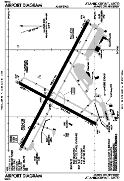
| Name: | Atlantic City International Airport |
| ICAO / IATA: | KACY / ACY |
| FAA: | ACY |
Details |
| Type: | Airport (Part 139 Class I) |
| Use: | Public/Civil |
| Latitude: | 39°27'27"N (39.457583) |
| Longitude: | 74°34'38"W (-74.577166) |
| Datum: | WGS 1984 |
| Elevation: | 74 ft (23 m) |
| Runways: | 2 |
| Longest: | 10000 × 150 ft (3048 × 45.5 m) |
Time |
| Timezone: | UTC+29:08 (DST+32:08) |
| Local Time: | |
Weather |
| METAR: | KACY | 041354Z AUTO 00000KT 1/4SM FG VV002 00/00 A3011 RMK AO2 SLP196 I1001 T00000000
|
| TAF: | KACY | 041120Z 0412/0512 VRB03KT 1/4SM FZFG VV002 TEMPO 0412/0414 2SM BR SCT003 SCT150
FM041400 VRB03KT 5SM BR SCT005 BKN150 TEMPO 0414/0416 1SM BR VV005
FM041700 VRB03KT P6SM BKN100
FM050300 VRB03KT 6SM BR BKN200
FM050600 VRB03KT 2SM BR BKN150
|
Related Locations |
| Nearby: | |
| Farthest: | YAUG: 11795 mi / 18982 km
Augusta [Augusta Airport], WA, AU |
Find: |
|
Other Information |
Maps:
|
Delays:
|
Links:
|
Sources:
|
|