| Location |
| City: | | Asheville, North Carolina, United States |
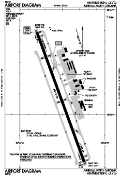
| Name: | Asheville Regional |
| ICAO / IATA: | KAVL / AVL |
| FAA: | AVL |
Details |
| Type: | Airport (Part 139 Class I) |
| Use: | Public/Civil |
| Latitude: | 35°26'10"N (35.436113) |
| Longitude: | 82°32'31"W (-82.542046) |
| Datum: | WGS 1984 |
| Elevation: | 2163 ft (659 m) |
| Runways: | 1 |
| Longest: | 8002 × 150 ft (2439 × 45.5 m) |
Time |
| Timezone: | UTC+29:08 (DST+32:08) |
| Local Time: | |
Weather |
| METAR: | KAVL | 041354Z 00000KT 8SM CLR 02/01 A3011 RMK AO2 SLP201 T00170006
|
| TAF: | KAVL | 041301Z 0413/0512 00000KT P6SM SKC
FM041400 VRB03KT P6SM FEW250
FM042100 19006KT P6SM FEW080 BKN200
FM050200 VRB02KT P6SM SCT050 BKN100
|
Related Locations |
| Nearby: | |
| Farthest: | YAUG: 11437 mi / 18406 km
Augusta [Augusta Airport], WA, AU |
Find: |
|
Other Information |
Maps:
|
Delays:
|
Links:
|
Sources:
|
|