| Location |
| City: | | Wilkes-Barre/Scranton, Pennsylvania, United States |
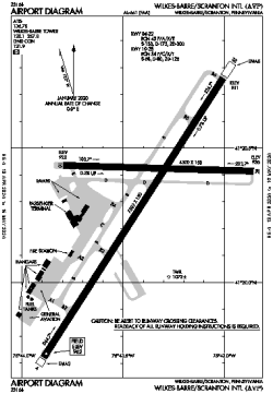
| Name: | Wilkes-Barre/Scranton International Airport |
| ICAO / IATA: | KAVP / AVP |
| FAA: | AVP |
Details |
| Type: | Airport (Part 139 Class I) |
| Use: | Public/Civil |
| Latitude: | 41°20'18"N (41.338472) |
| Longitude: | 75°43'24"W (-75.723388) |
| Datum: | WGS 1984 |
| Elevation: | 961 ft (293 m) |
| Runways: | 2 |
| Longest: | 7502 × 150 ft (2287 × 45.5 m) |
Time |
| Timezone: | UTC+29:08 (DST+32:08) |
| Local Time: | |
Weather |
| METAR: | KAVP | 041354Z 00000KT 7SM SCT060 04/01 A3008 RMK AO2 SLP191 T00440006
|
| TAF: | KAVP | 041132Z 0412/0512 VRB03KT P6SM SCT250 TEMPO 0412/0413 5SM BR
FM050100 VRB03KT P6SM BKN250
FM050800 21005KT P6SM BKN050
|
Related Locations |
| Nearby: | |
| Farthest: | YAUG: 11672 mi / 18784 km
Augusta [Augusta Airport], WA, AU |
Find: |
|
Other Information |
Maps:
|
Delays:
|
Links:
|
Sources:
|
|