| Location |
| City: | | Bismarck, North Dakota, United States |
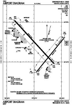
| Name: | Bismarck Municipal Airport |
| ICAO / IATA: | KBIS / BIS |
| FAA: | BIS |
Details |
| Type: | Airport (Part 139 Class I) |
| Use: | Public/Civil |
| Latitude: | 46°46'22"N (46.772734) |
| Longitude: | 100°44'45"W (-100.745737) |
| Datum: | WGS 1984 |
| Elevation: | 1661 ft (506 m) |
| Runways: | 2 |
| Longest: | 8794 × 150 ft (2680 × 45.5 m) |
Time |
| Timezone: | UTC+28:08 (DST+31:08) |
| Local Time: | |
Weather |
| METAR: | KBIS | 041352Z 34009KT 7SM -SN OVC070 M22/M26 A3011 RMK AO2 SLP248 P0000 T12171261 $
|
| TAF: | KBIS | 041124Z 0412/0512 34012KT P6SM SCT015 OVC070 TEMPO 0412/0415 BKN025
FM041600 33011G19KT P6SM SCT110
FM050100 VRB04KT P6SM BKN080
FM050300 04005KT P6SM VCSH OVC050
FM050600 VRB04KT P6SM VCSH BKN016
|
Related Locations |
| Nearby: | |
| Farthest: | YCSK: 10661 mi / 17157 km
Casey Station [Casey Station Skiway], Wilkes Land, AQ |
Find: |
|
Other Information |
Maps:
|
Delays:
|
Links:
|
Sources:
|
|