| Location |
| City: | | Boston, Massachusetts, United States |
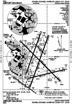
| Name: | General Edward Lawrence Logan International Airport |
| ICAO / IATA: | KBOS / BOS |
| FAA: | BOS |
Details |
| Type: | Airport (Part 139 Class I) |
| Use: | Public/Civil |
| Latitude: | 42°21'47"N (42.362944) |
| Longitude: | 71°00'23"W (-71.006388) |
| Datum: | WGS 1984 |
| Elevation: | 19 ft (6 m) |
| Runways: | 6 |
| Longest: | 10083 × 150 ft (3073 × 45.5 m) |
Time |
| Timezone: | UTC+29:08 (DST+32:08) |
| Local Time: | |
Weather |
| METAR: | KBOS | 041354Z 22011KT 10SM FEW110 BKN250 07/01 A3006 RMK AO2 SLP177 T00670006
|
| TAF: | KBOS | 041140Z 0412/0518 22008KT P6SM FEW250
FM050000 21006KT P6SM FEW250
FM051400 22010KT P6SM SCT090
FM051600 23009KT P6SM SCT140
|
Related Locations |
| Nearby: | |
| Farthest: | YAUG: 11786 mi / 18968 km
Augusta [Augusta Airport], WA, AU |
Find: |
|
Other Information |
Maps:
|
Delays:
|
Links:
|
Sources:
|
|