| Location |
| City: | | Columbus, Mississippi, United States |
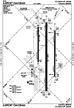
| Name: | Columbus AFB |
| ICAO / IATA: | KCBM / CBM |
| FAA: | CBM |
Details |
| Type: | Airport (Airfield) |
| Use: | Military |
| Latitude: | 33°38'43"N (33.645175) |
| Longitude: | 88°26'45"W (-88.445918) |
| Datum: | WGS 1984 |
| Elevation: | 218 ft (66 m) |
| Runways: | 3 |
| Longest: | 12004 × 300 ft (3659 × 91.5 m) |
Time |
| Timezone: | UTC+28:08 (DST+31:08) |
| Local Time: | |
Weather |
| METAR: | KCBM | 041356Z AUTO 17006KT 10SM OVC005 14/13 A3001 RMK AO2 DZE00 SLP165 P0000 T01390131 $
|
| TAF: | KCBM | 040900Z 0409/0515 17006KT 4800 BR BKN020 510051 QNH2994INS BECMG 0411/0412 18006KT 4800 -DZ BR OVC010 510051 QNH2996INS BECMG 0417/0418 17009KT 8000 BR OVC015 510051 QNH2991INS BECMG 0420/0421 17009KT 6000 BR OVC010 510051 QNH2993INS BECMG 0508/0509 17006KT 3200 BR OVC009 510051 QNH2997INS TX19/0421Z TN10/0409Z
|
Related Locations |
| Nearby: | |
| Farthest: | MQZ: 11092 mi / 17851 km
Margaret River [Margaret River Airport], WA, AU |
Find: |
|
Other Information |
Maps:
|
Links:
|
Sources:
|
|