| Location |
| City: | | Camarillo, California, United States |
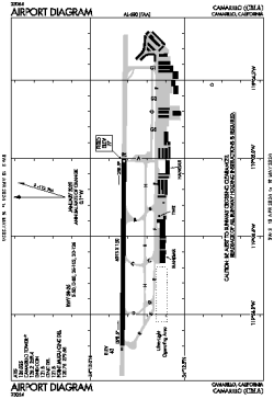
| ICAO: | KCMA |
| FAA: | CMA |
Details |
| Type: | Airport (Airfield) |
| Use: | Public/Civil |
| Latitude: | 34°12'50"N (34.213758) |
| Longitude: | 119°05'40"W (-119.094353) |
| Datum: | WGS 1984 |
| Elevation: | 76 ft (23 m) |
| Runways: | 1 |
| Longest: | 6013 × 150 ft (1833 × 45.5 m) |
Time |
| Timezone: | UTC+26:08 (DST+29:08) |
| Local Time: | |
Weather |
| METAR: | KCMA | 041355Z AUTO 19006KT 10SM BKN080 BKN120 13/09 A2980 RMK AO2 RAE01 SLP098 P0000 T01330094
|
| TAF: | KCMA | 041146Z 0412/0512 22010KT 6SM -SHRA BR SCT015 OVC035
FM041700 22010KT 4SM RA BR OVC015
FM042100 25015G23KT 5SM -RA BR SCT015 OVC025
FM050100 25015KT P6SM -SHRA BKN025 OVC040
FM050500 27010KT P6SM -SHRA SCT025 OVC040
|
Related Locations |
| Nearby: | |
| Farthest: | ZSE: 11483 mi / 18480 km
St-Pierre (St-Pierre de la Réunion) [Pierrefonds], RE |
Find: |
|
Other Information |
Maps:
|
Links:
|
Sources:
|
|