| Location |
| City: | | Champaign/Urbana, Illinois, United States |
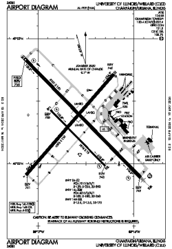
| Name: | University of Illinois/Willard Airport |
| ICAO / IATA: | KCMI / CMI |
| FAA: | CMI |
Details |
| Type: | Airport (Part 139 Class I) |
| Use: | Public/Civil |
| Latitude: | 40°02'19"N (40.038561) |
| Longitude: | 88°16'36"W (-88.276538) |
| Datum: | WGS 1984 |
| Elevation: | 754 ft (230 m) |
| Runways: | 3 |
| Longest: | 8101 × 150 ft (2469 × 45.5 m) |
Time |
| Timezone: | UTC+28:08 (DST+31:08) |
| Local Time: | |
Weather |
| METAR: | KCMI | 041353Z 18014G23KT 6SM BR OVC005 09/09 A2976 RMK AO2 PK WND 17027/1319 SLP079 T00940094
|
| TAF: | KCMI | 041256Z 0413/0512 18016G24KT P6SM SCT010 OVC040 WS015/21045KT TEMPO 0413/0415 OVC009
FM041500 19016G24KT P6SM VCSH OVC015
FM041700 19015KT 4SM -SHRA BR OVC008
FM042000 23013KT P6SM VCSH OVC006
FM042300 29011KT P6SM BKN008
FM050400 32011KT P6SM SCT012
|
Related Locations |
| Nearby: | |
| Farthest: | YAUG: 11095 mi / 17855 km
Augusta [Augusta Airport], WA, AU |
Find: |
|
Other Information |
Maps:
|
Links:
|
Sources:
|
|