| Location |
| City: | | Cahokia/St. Louis, Illinois, United States |
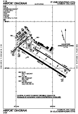
| Name: | St. Louis Downtown Airport |
| ICAO / IATA: | KCPS / CPS |
| FAA: | CPS |
Details |
| Type: | Airport (Part 139 Class IV) |
| Use: | Public/Civil |
| Latitude: | 38°34'13"N (38.570361) |
| Longitude: | 90°09'18"W (-90.155082) |
| Datum: | WGS 1984 |
| Elevation: | 412 ft (126 m) |
| Runways: | 3 |
| Longest: | 7002 × 150 ft (2134 × 45.5 m) |
Time |
| Timezone: | UTC+28:08 (DST+31:08) |
| Local Time: | |
Weather |
| METAR: | KCPS | 041353Z 14006KT 10SM OVC023 12/11 A2976 RMK AO2 SLP078 T01220106
|
| TAF: | KCPS | 041120Z 0412/0512 18009KT P6SM SCT015 OVC020
FM041400 18008KT P6SM OVC018
FM041800 23009KT P6SM VCSH OVC014
FM042200 32012G20KT P6SM OVC008
FM050000 33012KT P6SM OVC015
FM050300 34005KT P6SM BKN015
|
Related Locations |
| Nearby: | |
| Farthest: | YAUG: 11007 mi / 17715 km
Augusta [Augusta Airport], WA, AU |
Find: |
|
Other Information |
Maps:
|
Links:
|
Sources:
|
|