| Location |
| City: | | Jacksonville, Florida, United States |
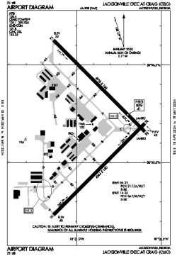
| Name: | Jacksonville Exec Airport at Craig |
| ICAO / IATA: | KCRG / CRG |
| FAA: | CRG |
Details |
| Type: | Airport (Airfield) |
| Use: | Public/Civil |
| Latitude: | 30°20'11"N (30.336333) |
| Longitude: | 81°30'52"W (-81.514443) |
| Datum: | WGS 1984 |
| Elevation: | 40 ft (12 m) |
| Runways: | 2 |
| Longest: | 4008 × 100 ft (1222 × 30.5 m) |
Time |
| Timezone: | UTC+29:08 (DST+32:08) |
| Local Time: | |
Weather |
| METAR: | KCRG | 041353Z 01004KT 10SM OVC009 14/13 A3010 RMK AO2 SLP191 T01390128
|
| TAF: | KCRG | 041121Z 0412/0512 VRB02KT P6SM SCT003 OVC009
FM041500 05004KT P6SM OVC010
FM041700 06005KT P6SM SCT015 BKN025
FM041900 09006KT P6SM BKN250
FM050000 VRB02KT P6SM SCT250
FM050700 00000KT 3SM BR FEW250
|
Related Locations |
| Nearby: | |
| Farthest: | USL: 11492 mi / 18494 km
Useless Loop, WA, AU |
Find: |
|
Other Information |
Maps:
|
Links:
|
Sources:
|
|