| Location |
| City: | | Charleston, West Virginia, United States |
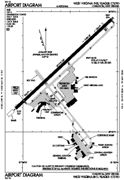
| Name: | West Virginia International Yeager |
| ICAO / IATA: | KCRW / CRW |
| FAA: | CRW |
Details |
| Type: | Airport (Part 139 Class I) |
| Use: | Public/Civil |
| Latitude: | 38°22'34"N (38.376013) |
| Longitude: | 81°35'34"W (-81.592893) |
| Datum: | WGS 1984 |
| Elevation: | 947 ft (289 m) |
| Runways: | 1 |
| Longest: | 6715 × 150 ft (2047 × 45.5 m) |
Time |
| Timezone: | UTC+29:08 (DST+32:08) |
| Local Time: | |
Weather |
| METAR: | KCRW | 041354Z 00000KT 10SM CLR 01/00 A3006 RMK AO2 SLP183 T00060000
|
| TAF: | KCRW | 041131Z 0412/0512 VRB03KT P6SM SKC
FM050100 19004KT P6SM BKN060
FM050300 21004KT 6SM -SHRA BKN030
FM050800 22005KT 5SM -SHRA BR OVC015
|
Related Locations |
| Nearby: | |
| Farthest: | YAUG: 11469 mi / 18457 km
Augusta [Augusta Airport], WA, AU |
Find: |
|
Other Information |
Maps:
|
Delays:
|
Links:
|
Sources:
|
|