| Location |
| City: | | Dubuque, Iowa, United States |
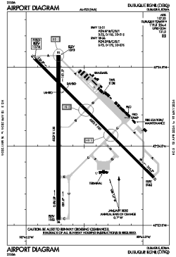
| Name: | Dubuque Regional |
| ICAO / IATA: | KDBQ / DBQ |
| FAA: | DBQ |
Details |
| Type: | Airport (Part 139 Class I) |
| Use: | Public/Civil |
| Latitude: | 42°24'07"N (42.402000) |
| Longitude: | 90°42'34"W (-90.709471) |
| Datum: | WGS 1984 |
| Elevation: | 1076 ft (328 m) |
| Runways: | 2 |
| Longest: | 6502 × 100 ft (1982 × 30.5 m) |
Time |
| Timezone: | UTC+28:08 (DST+31:08) |
| Local Time: | |
Weather |
| METAR: | KDBQ | 041418Z 22009KT 1/4SM R36/1200V1800FT FG OVC003 06/06 A2963 RMK AO2 T00560056
|
| TAF: | KDBQ | 041134Z 0412/0512 19010KT 5SM -SHRA BR BKN025 OVC040
FM041300 21010KT 3SM BR VCSH OVC010 TEMPO 0413/0417 1SM -SHRA OVC006
FM041700 30014G23KT P6SM BKN012
FM042000 30015G24KT P6SM SCT030
FM050000 31014KT P6SM FEW250
|
Related Locations |
| Nearby: | |
| Farthest: | YAUG: 10937 mi / 17602 km
Augusta [Augusta Airport], WA, AU |
Find: |
|
Other Information |
Maps:
|
Delays:
|
Links:
|
Sources:
|
|