| Location |
| City: | | Kemerovo, Kemerovskaya, Russian Federation (Russia) |
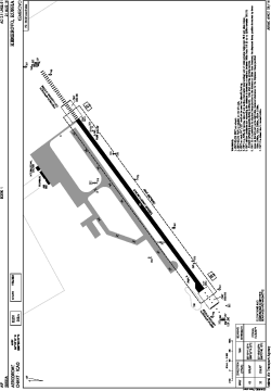
| Name: | Kemerovo International Airport |
| ICAO / IATA: | UNEE / KEJ |
Details |
| Type: | Airport (Aerodrome, Airfield) |
| Use: | Public/Civil |
| Latitude: | 55°16'12"N (55.270000) |
| Longitude: | 86°06'27"E (86.107500) |
| Elevation: | 873 ft (266 m) |
| Runways: | 1 |
| Longest: | 10499 × 197 ft (3200 × 60 m) |
Time |
| Timezone: | UTC+7 (DST+8) |
Weather |
| METAR: | UNEE | 041400Z 33005MPS 8000 NSC M31/M36 Q1034 R23/851038 NOSIG RMK QFE752
|
| TAF: | UNEE | 041400Z 0415/0515 33003MPS 4000 FU NSC TEMPO 0415/0418 1200 FU SCT003 TEMPO 0418/0503 0400 FU BKN002
|
Related Locations |
| Nearby: | |
| Farthest: | PNT: 11525 mi / 18547 km
Puerto Natales [Teniente Julio Gallardo], MA, CL |
Find: |
|
Other Information |
Maps:
|
Links:
|
Sources:
|
|