| Location |
| City: | | Falmouth, Massachusetts, United States |
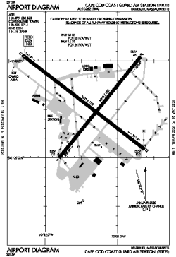
| Name: | Cape Cod Coast Guard Air Station (Otis ANGB, Otis AFB) |
| ICAO / IATA: | KFMH / FMH |
| FAA: | FMH |
Details |
| Type: | Airport (Airfield) |
| Use: | Military |
| Latitude: | 41°39'33"N (41.659139) |
| Longitude: | 70°31'22"W (-70.522805) |
| Datum: | WGS 1984 |
| Elevation: | 130 ft (40 m) |
| Runways: | 2 |
| Longest: | 9501 × 150 ft (2896 × 45.5 m) |
Time |
| Timezone: | UTC+29:08 (DST+32:08) |
| Local Time: | |
Weather |
| METAR: | KFMH | 041415Z 23009KT 3SM BR OVC003 06/06 A3010 RMK AO2
|
| TAF: | KFMH | 041405Z 0414/0512 23008KT 2SM BR OVC003
FM041700 23009KT 4SM BR BKN004
FM050300 VRB03KT 3SM BR BKN010
FM051000 21004KT P6SM BKN015
FM051100 21005KT P6SM BKN025
|
Related Locations |
| Nearby: | |
| Farthest: | YAUG: 11841 mi / 19056 km
Augusta [Augusta Airport], WA, AU |
Find: |
|
Other Information |
Maps:
|
Links:
|
Sources:
|
|