| Location |
| City: | | Topeka, Kansas, United States |
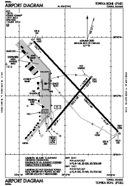
| Name: | Topeka Regional |
| ICAO / IATA: | KFOE / FOE |
| FAA: | FOE |
Details |
| Type: | Airport (Part 139 Class IV) |
| Use: | Public/Civil |
| Latitude: | 38°57'03"N (38.950949) |
| Longitude: | 95°39'49"W (-95.663613) |
| Datum: | WGS 1984 |
| Elevation: | 1077 ft (328 m) |
| Runways: | 2 |
| Longest: | 12803 × 150 ft (3902 × 45.5 m) |
Time |
| Timezone: | UTC+28:08 (DST+31:08) |
| Local Time: | |
Weather |
| METAR: | KFOE | 041353Z 34020G29KT 9SM OVC011 M02/M04 A2985 RMK AO2 PK WND 32032/1332 SLP110 T10221044
|
| TAF: | KFOE | 041133Z 0412/0512 32020G29KT P6SM OVC005
FM041500 35018G26KT P6SM BKN012
FM041600 35014G23KT P6SM FEW012
FM042100 35011KT P6SM FEW250
FM050900 05008KT P6SM FEW020 BKN200
|
Related Locations |
| Nearby: | |
| Farthest: | YAUG: 10709 mi / 17235 km
Augusta [Augusta Airport], WA, AU |
Find: |
|
Other Information |
Maps:
|
Delays:
|
Links:
|
Sources:
|
|