| Location |
| City: | | Atlanta, Georgia, United States |
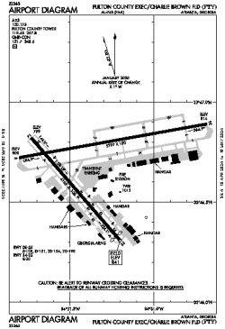
| Name: | Fulton County Exec/Charlie Brown Field |
| ICAO / IATA: | KFTY / FTY |
| FAA: | FTY |
Details |
| Type: | Airport (Airfield) |
| Use: | Public/Civil |
| Latitude: | 33°46'45"N (33.779126) |
| Longitude: | 84°31'17"W (-84.521365) |
| Datum: | WGS 1984 |
| Elevation: | 841 ft (256 m) |
| Runways: | 2 |
| Longest: | 5797 × 100 ft (1767 × 30.5 m) |
Time |
| Timezone: | UTC+29:08 (DST+32:08) |
| Local Time: | |
Weather |
| METAR: | KFTY | 041353Z 05004KT 1SM BR OVC003 07/06 A3010 RMK AO2 CIG 002V006 SLP192 T00720061
|
| TAF: | KFTY | 041353Z 0414/0512 00000KT 6SM BR SCT006 SCT250 TEMPO 0414/0415 2SM BR BKN006
FM041500 00000KT P6SM FEW015 SCT200
FM041700 VRB03KT P6SM SCT040 BKN120
FM050200 00000KT P6SM BKN025
FM050400 00000KT P6SM BKN015
FM050700 VRB03KT 5SM BR VCSH BKN008
|
Related Locations |
| Nearby: | |
| Farthest: | MQZ: 11318 mi / 18214 km
Margaret River [Margaret River Airport], WA, AU |
Find: |
|
Other Information |
Maps:
|
Delays:
|
Links:
|
Sources:
|
|