| Location |
| City: | | Fort Wayne, Indiana, United States |
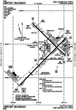
| Name: | Fort Wayne International Airport |
| ICAO / IATA: | KFWA / FWA |
| FAA: | FWA |
Details |
| Type: | Airport (Part 139 Class I) |
| Use: | Public/Civil |
| Latitude: | 40°58'42"N (40.978472) |
| Longitude: | 85°11'43"W (-85.195166) |
| Datum: | WGS 1984 |
| Elevation: | 814 ft (248 m) |
| Runways: | 3 |
| Longest: | 11981 × 150 ft (3652 × 45.5 m) |
Time |
| Timezone: | UTC+29:08 (DST+32:08) |
| Local Time: | |
Weather |
| METAR: | KFWA | 041354Z 18010KT 10SM FEW050 SCT065 BKN100 BKN240 09/07 A2984 RMK AO2 SLP109 T00890067
|
| TAF: | KFWA | 041129Z 0412/0512 18010KT P6SM BKN080 WS014/22040KT
FM041800 18013KT 5SM -SHRA BR OVC012 WS020/23045KT
FM042000 20013KT 3SM -SHRA BR OVC006 WS020/23040KT TEMPO 0420/0424 2SM SHRA BR
FM050300 29010KT P6SM OVC008
|
Related Locations |
| Nearby: | |
| Farthest: | YAUG: 11238 mi / 18086 km
Augusta [Augusta Airport], WA, AU |
Find: |
|
Other Information |
Maps:
|
Delays:
|
Links:
|
Sources:
|
|