| Location |
| City: | | Fort Drum, New York, United States |
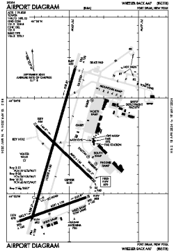
| Name: | Wheeler-Sack AAF Airport |
| ICAO: | KGTB |
| FAA: | GTB |
Details |
| Type: | Airport (Airfield) |
| Use: | Military |
| Latitude: | 44°03'20"N (44.055611) |
| Longitude: | 75°43'12"W (-75.719893) |
| Datum: | WGS 1984 |
| Elevation: | 689 ft (210 m) |
| Runways: | 3 |
| Longest: | 10000 × 150 ft (3048 × 45.5 m) |
Time |
| Timezone: | UTC+29:08 (DST+32:08) |
| Local Time: | |
Weather |
| METAR: | KGTB | 041416Z AUTO 21005KT 2 1/2SM -DZ BR BKN009 OVC017 04/03 A2995 RMK AO2 VIS 2 1/2V4 DZE1356RAB1356E05DZB05 CIG 006 RWY03 SLP148
|
| TAF: | KGTB | 040900Z 0409/0515 20009KT 8000 -RA BR OVC019 QNH2990INS BECMG 0416/0417 VRB06KT 9000 BR OVC010 QNH3002INS BECMG 0420/0421 18006KT 9999 NSW BKN020 QNH3002INS BECMG 0503/0504 18012KT 6000 -RA OVC015 QNH2996INS BECMG 0511/0512 25015G20KT 9000 -DZ OVC005 QNH2997INS TX09/0421Z TN06/0409Z
|
Related Locations |
| Nearby: | |
| Farthest: | YAUG: 11547 mi / 18584 km
Augusta [Augusta Airport], WA, AU |
Find: |
|
Other Information |
Maps:
|
Links:
|
Sources:
|
|