| Location |
| City: | | Peru, Indiana, United States |
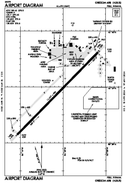
| Name: | Grissom ARB |
| ICAO / IATA: | KGUS / GUS |
| FAA: | GUS |
Details |
| Type: | Airport (Airfield) |
| Use: | Public/Civil, Military |
| Latitude: | 40°38'53"N (40.648092) |
| Longitude: | 86°09'08"W (-86.152118) |
| Datum: | WGS 1984 |
| Elevation: | 810 ft (247 m) |
| Runways: | 1 |
| Longest: | 12501 × 200 ft (3810 × 61 m) |
Time |
| Timezone: | UTC+29:08 (DST+32:08) |
| Local Time: | |
Weather |
| METAR: | KGUS | 041356Z AUTO 17010KT 10SM OVC095 08/08 A2980 RMK AO2 SLP098 T00830083 $
|
| TAF: | KGUS | 040300Z 0403/0509 18009KT 9999 FEW015 QNH2985INS BECMG 0405/0406 17009KT 8000 BR OVC006 QNH2978INS BECMG 0414/0415 18012KT 1600 -SHRA OVC002 QNH2970INS BECMG 0421/0422 18012KT 1600 BR OVC003 QNH2972INS BECMG 0506/0507 18012KT 3200 BR OVC007 QNH2993INS TX10/0420Z TN04/0410Z
|
Related Locations |
| Nearby: | |
| Farthest: | YAUG: 11196 mi / 18018 km
Augusta [Augusta Airport], WA, AU |
Find: |
|
Other Information |
Maps:
|
Links:
|
Sources:
|
|