| Location |
| City: | | Hammond, Louisiana, United States |
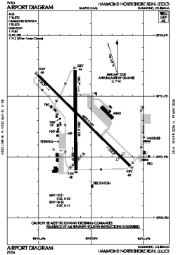
| Name: | Hammond Northshore Regional |
| ICAO: | KHDC |
| FAA: | HDC |
Details |
| Type: | Airport (Airfield) |
| Use: | Public/Civil |
| Latitude: | 30°31'18"N (30.521687) |
| Longitude: | 90°25'06"W (-90.418379) |
| Datum: | WGS 1984 |
| Elevation: | 46 ft (14 m) |
| Runways: | 2 |
| Longest: | 6502 × 100 ft (1982 × 30.5 m) |
Time |
| Timezone: | UTC+28:08 (DST+31:08) |
| Local Time: | |
Weather |
| METAR: | KHDC | 041415Z AUTO 13003KT 7SM BKN003 OVC012 16/16 A3001 RMK AO2
|
| TAF: | KHDC | 041128Z 0412/0512 00000KT 1/2SM FG OVC003 TEMPO 0412/0415 1/4SM FG VV002
FM041500 VRB03KT 2SM BR OVC004
FM041800 17005KT P6SM OVC008
FM050600 VRB03KT 4SM BR OVC003
FM050800 00000KT 1/2SM FG OVC002
|
Related Locations |
| Nearby: | |
| Farthest: | CCK: 11088 mi / 17844 km
West Island (Pulau Panjang) [Cocos (Keeling) Islands], CC |
Find: |
|
Other Information |
Maps:
|
Links:
|
Sources:
|
|