| Location |
| City: | | Huron, South Dakota, United States |
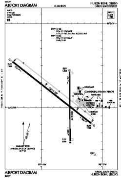
| Name: | Huron Regional |
| ICAO / IATA: | KHON / HON |
| FAA: | HON |
Details |
| Type: | Airport (Airfield) |
| Use: | Public/Civil |
| Latitude: | 44°23'07"N (44.385194) |
| Longitude: | 98°13'43"W (-98.228555) |
| Datum: | WGS 1984 |
| Elevation: | 1288 ft (393 m) |
| Runways: | 2 |
| Longest: | 7201 × 100 ft (2195 × 30.5 m) |
Time |
| Timezone: | UTC+28:08 (DST+31:08) |
| Local Time: | |
Weather |
| METAR: | KHON | 041404Z AUTO 32021KT 4SM HZ SCT014 M21/M24 A3007 RMK AO2 PK WND 32026/1403 T12061244
|
| TAF: | KHON | 041132Z 0412/0512 32019G27KT 4SM BLSN SCT190
FM041500 32016G24KT P6SM SCT100
FM050000 35008KT P6SM BKN110
FM050500 02006KT 6SM -SN OVC025
FM050800 02007KT 4SM -SN OVC018
|
Related Locations |
| Nearby: | |
| Farthest: | YCSK: 10570 mi / 17011 km
Casey Station [Casey Station Skiway], Wilkes Land, AQ |
Find: |
|
Other Information |
Maps:
|
Links:
|
Sources:
|
|