| Location |
| City: | | Mary Esther, Florida, United States |
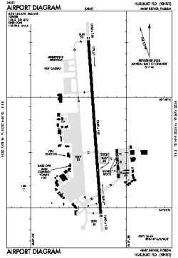
| Name: | Hurlburt Field |
| ICAO: | KHRT |
| FAA: | HRT |
Details |
| Type: | Airport (Airfield) |
| Use: | Military |
| Latitude: | 30°25'44"N (30.428922) |
| Longitude: | 86°41'20"W (-86.688807) |
| Datum: | WGS 1984 |
| Elevation: | 36 ft (11 m) |
| Runways: | 1 |
| Longest: | 9600 × 150 ft (2926 × 45.5 m) |
Time |
| Timezone: | UTC+28:08 (DST+31:08) |
| Local Time: | |
Weather |
| METAR: | KHRT | 041356Z 10004KT 10SM SCT160 BKN200 15/15 A3005 RMK AO2A SLP178 T01540149 $
|
| TAF: | KHRT | 041000Z 0410/0516 09005KT 4800 BR BKN008 QNH3000INS TEMPO 0410/0414 06003KT 1200 FG BKN005 OVC010 BECMG 0417/0418 14008KT 9999 NSW BKN010 QNH3007INS BECMG 0420/0421 15007KT 9999 BKN020 QNH3003INS BECMG 0503/0504 12005KT 4800 BR BKN006 QNH3005INS TX19/0421Z TN14/0412Z
|
Related Locations |
| Nearby: | |
| Farthest: | USL: 11188 mi / 18005 km
Useless Loop, WA, AU |
Find: |
|
Other Information |
Maps:
|
Links:
|
Sources:
|
|