| Location |
| City: | | Homestead, Florida, United States |
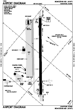
| Name: | Homestead ARB |
| ICAO / IATA: | KHST / HST |
| FAA: | HST |
Details |
| Type: | Airport (Airfield) |
| Use: | Military |
| Latitude: | 25°29'19"N (25.488551) |
| Longitude: | 80°23'01"W (-80.383565) |
| Datum: | WGS 1984 |
| Elevation: | 5 ft (2 m) |
| Runways: | 1 |
| Longest: | 11202 × 300 ft (3414 × 91.5 m) |
Time |
| Timezone: | UTC+29:08 (DST+32:08) |
| Local Time: | |
Weather |
| METAR: | KHST | 041356Z AUTO 33006KT 10SM OVC010 20/18 A3005 RMK AO2 SLP179 T01980177 FZRANO $
|
| TAF: | KHST | 040800Z 0408/0514 33006KT 8000 BR BKN025 QNH2996INS TEMPO 0411/0414 3200 BR BKN015 BECMG 0415/0416 04006KT 9999 NSW SCT025 BKN160 QNH3000INS BECMG 0500/0501 09004KT 9999 SCT004 OVC018 QNH3003INS BECMG 0504/0505 03004KT 6000 BR OVC004 QNH3006INS TX26/0419Z TN19/0410Z
|
Related Locations |
| Nearby: | |
| Farthest: | USL: 11587 mi / 18648 km
Useless Loop, WA, AU |
Find: |
|
Other Information |
Maps:
|
Links:
|
Sources:
|
|