| Location |
| City: | | Huntington, West Virginia, United States |
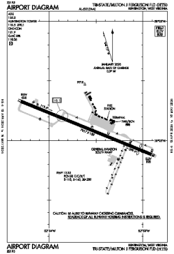
| Name: | Tri-State/Milton J Ferguson Field |
| ICAO / IATA: | KHTS / HTS |
| FAA: | HTS |
Details |
| Type: | Airport (Part 139 Class I) |
| Use: | Public/Civil |
| Latitude: | 38°22'07"N (38.368508) |
| Longitude: | 82°33'37"W (-82.560359) |
| Datum: | WGS 1984 |
| Elevation: | 828 ft (252 m) |
| Runways: | 1 |
| Longest: | 7017 × 150 ft (2139 × 45.5 m) |
Time |
| Timezone: | UTC+29:08 (DST+32:08) |
| Local Time: | |
Weather |
| METAR: | KHTS | 041351Z 00000KT 10SM CLR 06/02 A3003 RMK AO2 SLP170 T00560022
|
| TAF: | KHTS | 041131Z 0412/0512 VRB03KT P6SM SKC
FM042300 19007KT P6SM BKN060
FM050200 20008KT 6SM -SHRA BKN030
FM050800 22005KT 5SM -SHRA BR OVC015
|
Related Locations |
| Nearby: | |
| Farthest: | YAUG: 11417 mi / 18375 km
Augusta [Augusta Airport], WA, AU |
Find: |
|
Other Information |
Maps:
|
Delays:
|
Links:
|
Sources:
|
|