| Location |
| City: | | Kingston, Jamaica |
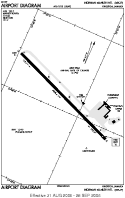
| Name: | Norman Manley International Airport |
| ICAO / IATA: | MKJP / KIN |
Details |
| Type: | Airport (Aerodrome, Airfield) |
| Use: | Public/Civil |
| Latitude: | 17°56'08"N (17.935667) |
| Longitude: | 76°47'15"W (-76.787499) |
| Datum: | WGS 1984 |
| Elevation: | 10 ft (3 m) |
| Runways: | 1 |
| Longest: | 8900 × 150 ft (2713 × 45.5 m) |
Time |
| Timezone: | UTC+29:08 (DST+31:08) |
| Local Time: | |
Weather |
| METAR: | MKJP | 041400Z 31005KT 9999 FEW024 26/19 Q1016
|
| TAF: | MKJP | 041115Z 0412/0512 35005KT 9999 FEW024 BECMG 0414/0416 15015KT BECMG 0501/0503 35005KT
|
Related Locations |
| Nearby: | |
| Farthest: | XCH: 11891 mi / 19136 km
Christmas Island, CX |
Find: |
|
Other Information |
Maps:
|
Sources:
|
|