| Location |
| City: | | Lafayette, Indiana, United States |
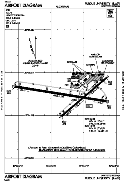
| Name: | Purdue University Airport |
| ICAO / IATA: | KLAF / LAF |
| FAA: | LAF |
Details |
| Type: | Airport (Part 139 Class IV) |
| Use: | Public/Civil |
| Latitude: | 40°24'44"N (40.412306) |
| Longitude: | 86°56'13"W (-86.936888) |
| Datum: | WGS 1984 |
| Elevation: | 605 ft (184 m) |
| Runways: | 2 |
| Longest: | 6600 × 150 ft (2012 × 45.5 m) |
Time |
| Timezone: | UTC+29:08 (DST+32:08) |
| Local Time: | |
Weather |
| METAR: | KLAF | 041354Z 20004KT 10SM OVC019 11/09 A2979 RMK AO2 SLP089 T01060089
|
| TAF: | KLAF | 041123Z 0412/0512 18009KT P6SM OVC060 WS020/22040KT
FM041400 19010G18KT P6SM VCSH OVC020 WS020/22040KT
FM041800 20012G22KT 3SM -RA OVC003
FM042200 23010KT P6SM VCSH OVC003
FM050000 28008KT P6SM OVC008
FM050300 31009KT P6SM BKN003
FM050800 34007KT P6SM SCT010 AMD LTD TO CLD VIS AND WIND TIL 041400
|
Related Locations |
| Nearby: | |
| Farthest: | YAUG: 11159 mi / 17959 km
Augusta [Augusta Airport], WA, AU |
Find: |
|
Other Information |
Maps:
|
Links:
|
Sources:
|
|