| Location |
| City: | | Hampton, Virginia, United States |
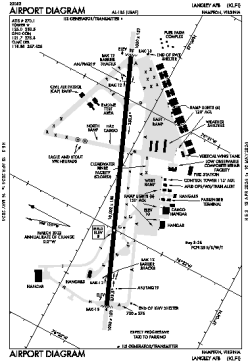
| Name: | Langley AFB |
| ICAO / IATA: | KLFI / LFI |
| FAA: | LFI |
Details |
| Type: | Airport (Airfield) |
| Use: | Military |
| Latitude: | 37°04'58"N (37.082886) |
| Longitude: | 76°21'38"W (-76.360538) |
| Datum: | WGS 1984 |
| Elevation: | 8 ft (2 m) |
| Runways: | 1 |
| Longest: | 10002 × 150 ft (3049 × 45.5 m) |
Time |
| Timezone: | UTC+29:08 (DST+32:08) |
| Local Time: | |
Weather |
| METAR: | KLFI | 041356Z AUTO 03007KT 10SM FEW110 09/05 A3005 RMK AO2 SLP183 T00910049 $
|
| TAF: | KLFI | 041000Z 0410/0516 VRB06KT 9999 BKN090 QNH3002INS TEMPO 0412/0414 8000 -RA BECMG 0414/0415 04009KT 9999 OVC050 QNH2994INS BECMG 0501/0502 VRB06KT 8000 BR SCT020 BKN035 QNH2991INS BECMG 0505/0506 30008KT 9999 NSW BKN030 QNH2987INS TX14/0421Z TN08/0410Z
|
Related Locations |
| Nearby: | |
| Farthest: | YAUG: 11768 mi / 18939 km
Augusta [Augusta Airport], WA, AU |
Find: |
|
Other Information |
Maps:
|
Links:
|
Sources:
|
|