| Location |
| City: | | Little Rock, Arkansas, United States |
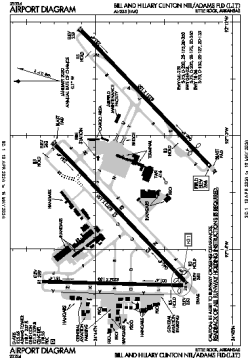
| Name: | Bill and Hillary Clinton National Airport/Adams Field |
| ICAO / IATA: | KLIT / LIT |
| FAA: | LIT |
Details |
| Type: | Airport (Part 139 Class I) |
| Use: | Public/Civil |
| Latitude: | 34°43'46"N (34.729441) |
| Longitude: | 92°13'29"W (-92.224776) |
| Datum: | WGS 1984 |
| Elevation: | 266 ft (81 m) |
| Runways: | 3 |
| Longest: | 8273 × 150 ft (2522 × 45.5 m) |
Time |
| Timezone: | UTC+28:08 (DST+31:08) |
| Local Time: | |
Weather |
| METAR: | KLIT | 041353Z 21009KT 10SM OVC011 18/16 A2985 RMK AO2 SLP110 T01780156
|
| TAF: | KLIT | 041259Z 0413/0512 19012KT P6SM OVC012
FM041600 21008G16KT P6SM OVC025
FM041800 22012KT P6SM BKN030
FM050000 VRB04KT P6SM SCT100 BKN250
FM050600 VRB03KT 4SM BR OVC012
|
Related Locations |
| Nearby: | |
| Farthest: | YAUG: 10886 mi / 17520 km
Augusta [Augusta Airport], WA, AU |
Find: |
|
Other Information |
Maps:
|
Delays:
|
Links:
|
Sources:
|
|