| Location |
| City: | | Jacksonville, Arkansas, United States |
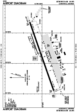
| Name: | Little Rock AFB |
| ICAO / IATA: | KLRF / LRF |
| FAA: | LRF |
Details |
| Type: | Airport (Airfield) |
| Use: | Military |
| Latitude: | 34°55'03"N (34.917512) |
| Longitude: | 92°08'42"W (-92.145000) |
| Datum: | WGS 1984 |
| Elevation: | 312 ft (95 m) |
| Runways: | 2 |
| Longest: | 12007 × 150 ft (3660 × 45.5 m) |
Time |
| Timezone: | UTC+28:08 (DST+31:08) |
| Local Time: | |
Weather |
| METAR: | KLRF | 041356Z AUTO 17003KT 10SM OVC011 17/17 A2984 RMK AO2 SLP106 T01740166 $
|
| TAF: | KLRF | 040700Z 0407/0513 14009KT 6000 BR OVC015 WS020/21035KT QNH2980INS BECMG 0414/0415 19012KT 9999 NSW BKN015 510062 QNH2982INS BECMG 0417/0418 19015G20KT 9999 BKN020 QNH2984INS BECMG 0422/0423 22006KT 9999 SCT020 510062 QNH2982INS BECMG 0506/0507 VRB06KT 8000 BR BKN007 QNH2991INS TX23/0421Z TN14/0407Z
|
Related Locations |
| Nearby: | |
| Farthest: | YAUG: 10892 mi / 17530 km
Augusta [Augusta Airport], WA, AU |
Find: |
|
Other Information |
Maps:
|
Links:
|
Sources:
|
|