| Location |
| City: | | Livermore, California, United States |
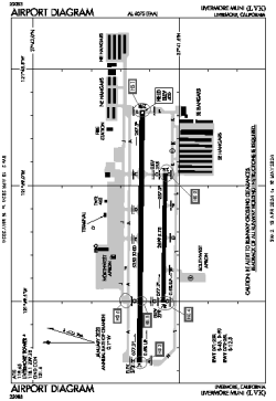
| Name: | Livermore Municipal Airport |
| ICAO / IATA: | KLVK / LVK |
| FAA: | LVK |
Details |
| Type: | Airport (Airfield) |
| Use: | Public/Civil |
| Latitude: | 37°41'36"N (37.693389) |
| Longitude: | 121°49'13"W (-121.820360) |
| Datum: | WGS 1984 |
| Elevation: | 399 ft (122 m) |
| Runways: | 2 |
| Longest: | 5253 × 100 ft (1601 × 30.5 m) |
Time |
| Timezone: | UTC+26:08 (DST+29:08) |
| Local Time: | |
Weather |
| METAR: | KLVK | 041411Z AUTO 23012KT 9SM SCT018 BKN027 BKN038 08/07 A2954 RMK AO2 RAE09 P0000 T00830067 $
|
| TAF: | KLVK | 041138Z 0412/0512 17010G20KT 4SM -RA OVC050
FM041500 22012KT P6SM -SHRA OVC050
FM042200 25015KT P6SM VCSH BKN050 OVC070
FM050200 24010KT P6SM -RA OVC025
|
Related Locations |
| Nearby: | |
| Farthest: | FTU: 11342 mi / 18252 km
Tolagnaro [Maurillac Airport (Fort Dauphin Airport)], MG |
Find: |
|
Other Information |
Maps:
|
Links:
|
Sources:
|
|