| Location |
| City: | | Orlando, Florida, United States |
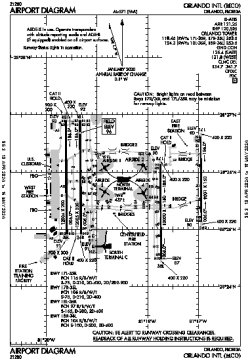
| Name: | Orlando International Airport |
| ICAO / IATA: | KMCO / MCO |
| FAA: | MCO |
Details |
| Type: | Airport (Part 139 Class I) |
| Use: | Public/Civil |
| Latitude: | 28°25'46"N (28.429389) |
| Longitude: | 81°18'32"W (-81.308999) |
| Datum: | WGS 1984 |
| Elevation: | 96 ft (29 m) |
| Runways: | 4 |
| Longest: | 12005 × 200 ft (3659 × 61 m) |
Time |
| Timezone: | UTC+29:08 (DST+32:08) |
| Local Time: | |
Weather |
| METAR: | KMCO | 041353Z 01005KT 10SM OVC006 14/13 A3009 RMK AO2 SLP189 T01440133
|
| TAF: | KMCO | 041321Z 0413/0518 03006KT P6SM OVC010
FM041500 04006KT P6SM SCT020 SCT180
FM050000 VRB03KT P6SM SCT150 SCT250
FM051500 05005KT P6SM FEW150 FEW250
|
Related Locations |
| Nearby: | |
| Farthest: | USL: 11528 mi / 18553 km
Useless Loop, WA, AU |
Find: |
|
Other Information |
Maps:
|
Delays:
|
Links:
|
Sources:
|
|