| Location |
| City: | | Memphis, Tennessee, United States |
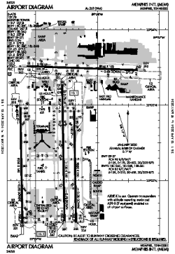
| Name: | Memphis International Airport |
| ICAO / IATA: | KMEM / MEM |
| FAA: | MEM |
Details |
| Type: | Airport (Part 139 Class I) |
| Use: | Public/Civil |
| Latitude: | 35°02'33"N (35.042411) |
| Longitude: | 89°58'36"W (-89.976678) |
| Datum: | WGS 1984 |
| Elevation: | 340 ft (104 m) |
| Runways: | 4 |
| Longest: | 11120 × 150 ft (3389 × 45.5 m) |
Time |
| Timezone: | UTC+28:08 (DST+31:08) |
| Local Time: | |
Weather |
| METAR: | KMEM | 041354Z 19011KT 10SM OVC009 15/14 A2990 RMK AO2 SLP123 T01500144 $
|
| TAF: | KMEM | 041126Z 0412/0518 18011G18KT P6SM VCSH SCT015 OVC025 TEMPO 0412/0416 6SM -SHRA BR BKN015
FM042000 20009KT P6SM VCSH FEW020 BKN035
FM050300 19006KT P6SM VCSH BKN030
FM050700 19004KT P6SM SCT007 BKN018 TEMPO 0509/0513 5SM BR BKN007
|
Related Locations |
| Nearby: | |
| Farthest: | YAUG: 11016 mi / 17728 km
Augusta [Augusta Airport], WA, AU |
Find: |
|
Other Information |
Maps:
|
Delays:
|
Links:
|
Sources:
|
|