| Location |
| City: | | Miami, Florida, United States |
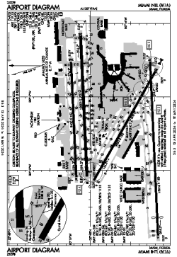
| Name: | Miami International Airport |
| ICAO / IATA: | KMIA / MIA |
| FAA: | MIA |
Details |
| Type: | Airport (Part 139 Class I) |
| Use: | Public/Civil |
| Latitude: | 25°47'43"N (25.795361) |
| Longitude: | 80°17'24"W (-80.290115) |
| Datum: | WGS 1984 |
| Elevation: | 9 ft (3 m) |
| Runways: | 4 |
| Longest: | 13016 × 150 ft (3967 × 45.5 m) |
Time |
| Timezone: | UTC+29:08 (DST+32:08) |
| Local Time: | |
Weather |
| METAR: | KMIA | 041419Z 34004KT 10SM OVC015 21/18 A3006 RMK AO2 T02060183
|
| TAF: | KMIA | 041402Z 0414/0518 32005KT P6SM SCT015 BKN035 TEMPO 0414/0416 BKN015 OVC025
FM041800 05007KT P6SM SCT020 BKN250
FM050000 VRB03KT P6SM FEW020 SCT250
|
Related Locations |
| Nearby: | |
| Farthest: | USL: 11595 mi / 18661 km
Useless Loop, WA, AU |
Find: |
|
Other Information |
Maps:
|
Delays:
|
Links:
|
Sources:
|
|