| Location |
| City: | | New Orléans, Louisiana, United States |
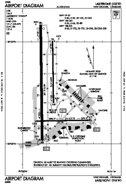
| Name: | Lakefront Airport |
| ICAO / IATA: | KNEW / NEW |
| FAA: | NEW |
Details |
| Type: | Airport (Airfield) |
| Use: | Public/Civil |
| Latitude: | 30°02'33"N (30.042417) |
| Longitude: | 90°01'42"W (-90.028249) |
| Datum: | WGS 1984 |
| Elevation: | 7 ft (2 m) |
| Runways: | 3 |
| Longest: | 6879 × 150 ft (2097 × 45.5 m) |
Time |
| Timezone: | UTC+28:08 (DST+31:08) |
| Local Time: | |
Weather |
| METAR: | KNEW | 041353Z 08003KT 1/4SM HZ OVC002 16/15 A3002 RMK AO2 SLP160 T01560150
|
| TAF: | KNEW | 041329Z 0413/0512 11004KT 5SM HZ OVC003 TEMPO 0413/0415 1/2SM FG VV002
FM041500 VRB04KT 3/4SM BR OVC002
FM050000 19005KT 1 1/2SM BR OVC007
FM050700 VRB04KT 1/2SM FG OVC002
FM050900 VRB03KT 2SM BR OVC003
|
Related Locations |
| Nearby: | |
| Farthest: | CCK: 11127 mi / 17907 km
West Island (Pulau Panjang) [Cocos (Keeling) Islands], CC |
Find: |
|
Other Information |
Maps:
|
Links:
|
Sources:
|
|