| Location |
| City: | | Jacksonville, North Carolina, United States |
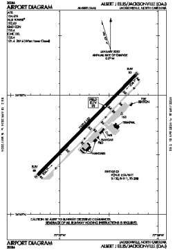
| Name: | Albert J Ellis Airport |
| ICAO / IATA: | KOAJ / OAJ |
| FAA: | OAJ |
Details |
| Type: | Airport (Part 139 Class I) |
| Use: | Public/Civil |
| Latitude: | 34°49'45"N (34.829167) |
| Longitude: | 77°36'44"W (-77.612138) |
| Datum: | WGS 1984 |
| Elevation: | 92 ft (28 m) |
| Runways: | 1 |
| Longest: | 7100 × 150 ft (2164 × 45.5 m) |
Time |
| Timezone: | UTC+29:08 (DST+32:08) |
| Local Time: | |
Weather |
| METAR: | KOAJ | 041356Z 33006KT 10SM -RA FEW048 SCT100 11/08 A3001 RMK AO2 SLP167 P0000 T01110083
|
| TAF: | KOAJ | 041123Z 0412/0512 34010G16KT P6SM -RA SCT025 OVC060
FM041400 34010G16KT P6SM VCSH SCT025 BKN035
FM041800 35008G13KT P6SM BKN120
FM042200 35007KT P6SM BKN150
FM050100 34003KT P6SM SCT250 AMD LTD TO CLD VIS AND WIND
|
Related Locations |
| Nearby: | |
| Farthest: | YAUG: 11716 mi / 18855 km
Augusta [Augusta Airport], WA, AU |
Find: |
|
Other Information |
Maps:
|
Links:
|
Sources:
|
|