| Location |
| City: | | Newport News, Virginia, United States |
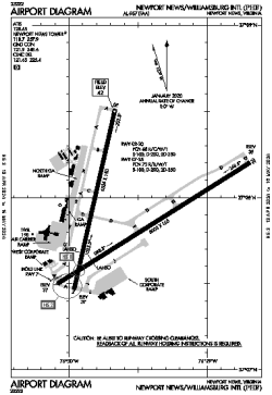
| Name: | Newport News/Williamsburg International Airport |
| ICAO / IATA: | KPHF / PHF |
| FAA: | PHF |
Details |
| Type: | Airport (Part 139 Class I) |
| Use: | Public/Civil |
| Latitude: | 37°07'55"N (37.131889) |
| Longitude: | 76°29'35"W (-76.492971) |
| Datum: | WGS 1984 |
| Elevation: | 42 ft (13 m) |
| Runways: | 2 |
| Longest: | 8003 × 150 ft (2439 × 45.5 m) |
Time |
| Timezone: | UTC+29:08 (DST+32:08) |
| Local Time: | |
Weather |
| METAR: | KPHF | 041354Z 03005KT 10SM SCT110 08/04 A3006 RMK AO2 SLP179 T00830039
|
| TAF: | KPHF | 041139Z 0412/0512 04005KT P6SM OVC100
FM041500 05006KT P6SM BKN100
FM050200 VRB02KT P6SM SCT250
|
Related Locations |
| Nearby: | |
| Farthest: | YAUG: 11760 mi / 18926 km
Augusta [Augusta Airport], WA, AU |
Find: |
|
Other Information |
Maps:
|
Delays:
|
Links:
|
Sources:
|
|