| Location |
| City: | | Pullman/Moscow, Washington, United States |
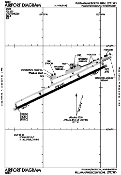
| Name: | Pullman/Moscow Regional |
| ICAO / IATA: | KPUW / PUW |
| FAA: | PUW |
Details |
| Type: | Airport (Part 139 Class I) |
| Use: | Public/Civil |
| Latitude: | 46°44'30"N (46.741691) |
| Longitude: | 117°06'42"W (-117.111618) |
| Datum: | WGS 1984 |
| Elevation: | 2566 ft (782 m) |
| Runways: | 1 |
| Longest: | 7100 × 150 ft (2164 × 45.5 m) |
Time |
| Timezone: | UTC+26:08 (DST+29:08) |
| Local Time: | |
Weather |
| METAR: | KPUW | 041353Z AUTO 12005KT 10SM BKN070 OVC085 00/M01 A2942 RMK AO2 SLP980 T00001011
|
| TAF: | KPUW | 041130Z 0412/0512 10008KT P6SM SCT025 OVC070 TEMPO 0412/0414 3SM -SN BKN025 OVC050
FM041500 09013KT P6SM OVC100
FM042100 07012KT P6SM BKN050 OVC100 TEMPO 0422/0502 5SM -SHSN
FM050200 05010KT 3SM -SN OVC020
FM051000 25006KT 2SM BR OVC008
|
Related Locations |
| Nearby: | |
| Farthest: | FAME: 11257 mi / 18117 km
Marion Island, Prince Edward Islands, WC, ZA |
Find: |
|
Other Information |
Maps:
|
Links:
|
Sources:
|
|